
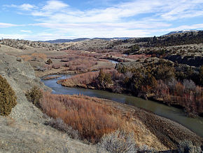
Sixteen Mile Creek
 |
| Near Maudlow, Montana Origin: 46°15'56"N 110°32'29"W Mouth: 46°06'20"N 111°23'52"W Basin countries: Broadwater, Gallatin and Meagher County Length: 69 miles (111 km) Mouth elevation: 3,963 feet (1,208 m) |
Sixteen Mile Creek (also known as Sixteen mile Creek), a tributary of the Missouri River, is 69 miles (111 km) long, in western Montana in the United States. If forms at the confluence of the Middle and South forks of Sixteen Mile Creek approximately 6 miles (9.7 km) east of Maudlow. The canyon through which it travels is known as "Sixteen Mile Canyon." The abandoned grade of the Chicago, Milwaukee, St. Paul and Pacific Railroad ("the Milwaukee Road") parallels the creek through the canyon; the Milwaukee Road called Sixteen Mile Canyon "Montana Canyon" in its promotional material.
Sixteen Mile Creek rises in the Lewis and Clark National Forest in the Crazy Mountains in southeastern Meagher County. It flows generally west, south of the Big Belt Mountains, and southwest, past Maudlow and joins the Missouri 6 mi (9 km) southeast of Toston, at the site of the ghost town of Lombard.
Sixteen-Mile Creek is one of the more historically important areas in Montana. Its name derives from the fact that it enters the Missouri River 16 miles downstream from Three Forks, Montana. The rail bed of the original Montana Railroad runs through this creek canyon, which includes some really outstanding scenery. The Milwaukee Road abandoned this line in 1980.